Starcore International Mines Ltd. has a 100% interest in the Ajax Property (“the property”). The property, approximately 1,718 hectares in size, hosts the Ajax Porphyry Molybdenum Deposit.
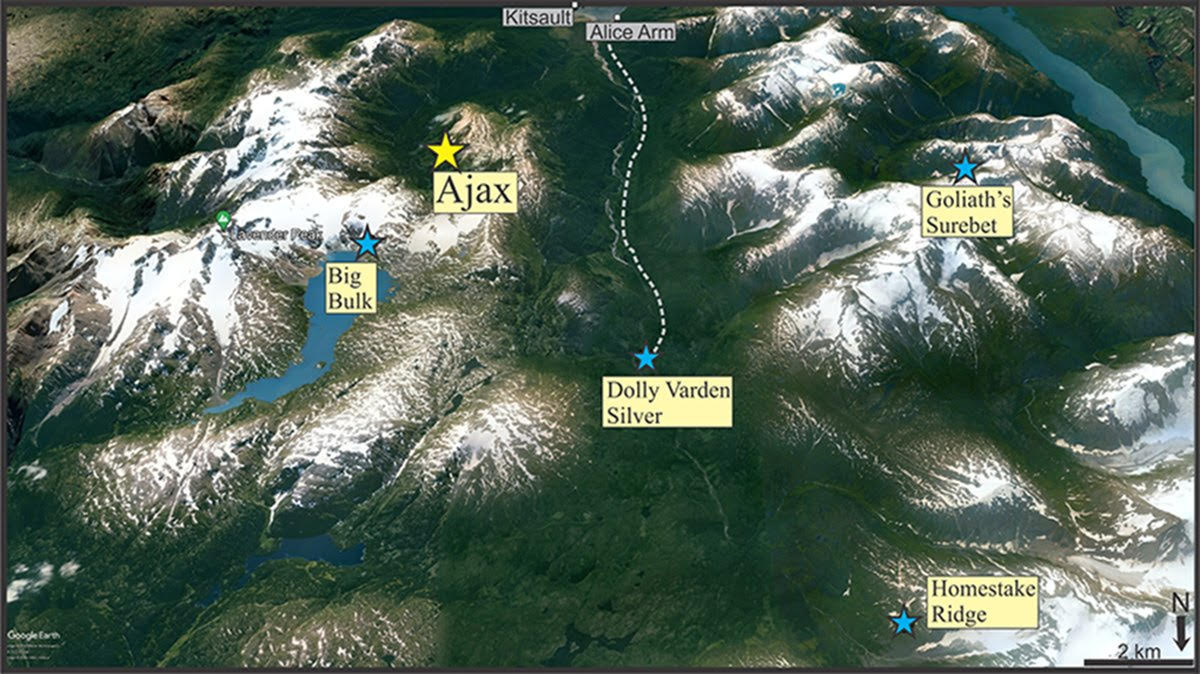
The property is located on the eastern flank of Mount McGuire, 60 km south of Stewart, B.C., 15 km northeast of Alice Arm. Alice Arm, a summer hamlet, is located on the north side of the east arm of Observatory Inlet. Kitsault, a semi-abandoned townsite located on the south side of the arm is on the B.C. Power Grid. There is good road access between Kitsault and Terrace 100 km to the south. In the 1960’s, there was a tote road from Alice Arm to the property that is no longer usable. Access is presently by helicopter.
Molybdenite was discovered on the property in 1965 by Newmont Mining Corp. (Newmont). Between 1965 and 1967 Newmont completed limited mapping, sampling, trenching and drilled 26 holes totalling 8100 m (26,578 feet) in length. From 1967 to 1990 minor exploration consisting of thin section and alteration studies and limited drill core sampling was completed. Starcore acquired the property through acquisition of Creston Moly from Bankruptcy in 2015.
The Ajax Property occurs along the western margin of the Stikinia Terrane of the North America Cordillera, immediately adjacent to the eastern margin of the Coast Plutonic Complex. The property is underlain by Jurassic Hazelton Group rocks consisting primarily of argillaceous sediments and minor interbedded andesite tuffs that locally has been intruded by four closely spaced stocks of quartz monzonite porphyry. The Ajax deposit occupies a rectangular area approximately 650 m x 600 m that ranges in elevation from 425 masl to 1050 masl. The mineralization is predominantly pyrrhotite and lesser molybdenite that typically comprises less than 2% of the rock by volume. Molybdenite is typically associated with quartz and occurs in pyrrhotite-bearing veinlets, in thin stringers and on fracture and shear surfaces. Areas of elevated molybdenite grades (>0.060% Mo) are characterized by a high fracture density where quartz vein stockwork is well developed. Lower grade material (0.030 to 0.060 % Mo), is found in areas of weaker fracturing and forms a broad halo around the higher grade zones, especially below the 762 m elevation contour.
Exploration at Ajax was concentrated in two drilling programs completed by Newmont Mines in 1967-68 (26 holes-8100.9 metres) and Tenajon Resources Corp 2005-2007 (22 holes-7258.6 metres). Following the 2007 an updated resource calculation was completed by Giroux Consultants.
During Starcore’s September 2021 limited field program, rock and soil sampling have revealed the potential for precious and base metal potential beyond the limits of the known molybdenum mineralization.
Three rock samples collected from mineralization exposed in old pits along the south spine of Mt. McGuire, about 1.3 km from the known molybdenum mineralization, assayed up to 4.1 grams per tonne (g/t) silver, 0.23% copper, over limit for analysis method (greater than 100 g/t) tungsten and 794 g/t cobalt. In addition, two quartz veins sampled downslope from these pits assayed over limit (greater than 100 g/t) silver and over limit (greater than 1%) lead and zinc and over limit (greater than 0.2%) bismuth. These samples have been resubmitted to the lab for analyses using an ore grade methodology. Mineralization sampled in the vicinity of a documented BC MINFILE occurrence Ida, northeast of Mt. McGuire peak, assayed over limit (greater than 100 g/t) tungsten, 1.1 g/t silver and anomalous molybdenum and copper.
Soil sampling during the 2021 fieldwork identified two areas to the southwest of the known molybdenum mineralization. The North Anomaly, as defined by the 50 ppm molybdenum in soil contour, is 300 metres (m) long by 500 m wide. It trends westerly and is open along strike to the east and west. The South Anomaly is a 700 m long and open up to 500 m wide, east-west trend of anomalous gold, silver, copper, lead, zinc, cobalt and arsenic in-soil values.
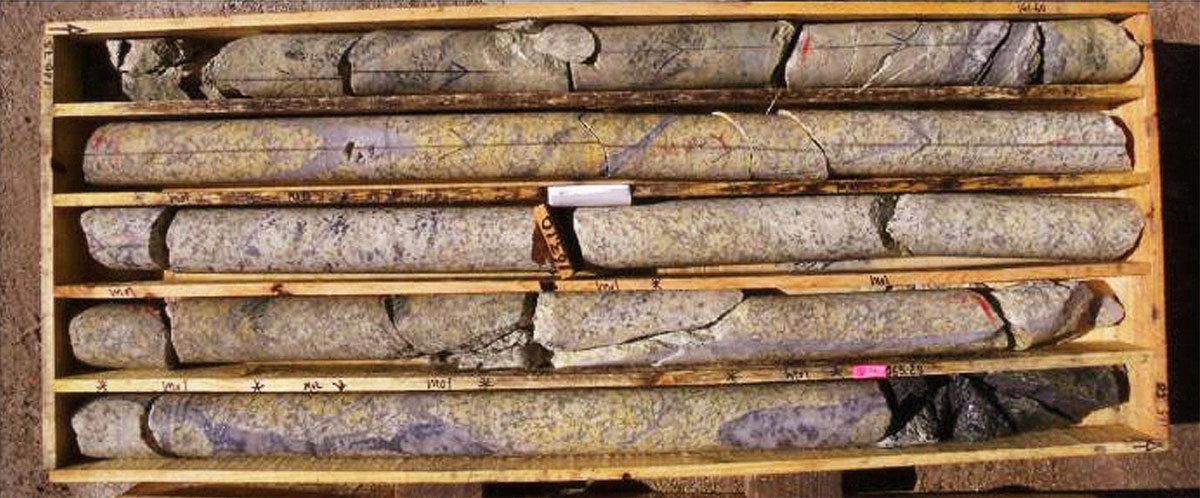
Mineralization is found exposed in old pits and trenches and in outcrop along the margins of ice and snow on the southeast spine and upper slopes of Mount McGuire. This mineralization is about 1.7 km southwest from the known porphyry molybdenum mineralization and up to 540 metres higher in elevation. Assay samples collected in 2022 include values high in silver, elevated copper, lead and zinc and anomalous cobalt and tungsten. The following table lists highlights from the 53-element inductively coupled plasma – emissions and mass spectrometry assay analyses.
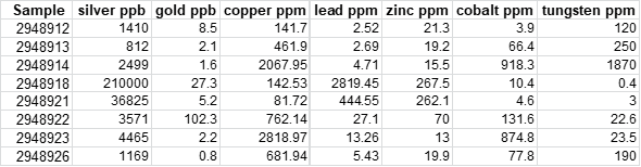
Table of selected assay results. Silver and gold are in parts per billion (ppb); other elements in parts per million (ppm).
Starcore is planning additional fieldwork for 2023 to further explore the potential of the higher level porphyry, transitional and vein mineralization including locating and sampling the 1926 underground workings at the Le Roy mineral occurrence that is situated on the Ajax property. Other styles of mineralization occur within the area such as at Dolly Varden, 12 km to the north-northwest, Big Bulk, 7 km north-northeast and Surebet, 17 km west. Starcore’s Ajax property is located within 1 to 3 km of the Triassic - Jurassic contact, termed the Red Line in this area, near which many of the Golden Triangle’s mineralized systems occur.